Mile Marker TX
MM 458.4Every county · Works offline · Free

All of Texas. One free app.

Mile markers to the tenth. Every 911 address. Who owns the land. Ranch roads, your own pins, your crew on the map, and a map that keeps working when the signal quits.
Coming soon · FreeApp Store for iPhone
See every feature
  • 42,059posted TxDOT mile markers
  • 12.1M911 street addresses
  • 254Texas counties
  • 0bars of signal needed
MM 1

Everything in one app

The things you'd otherwise juggle across a map app, a county records site and a notebook in the truck. Tap any of them to see how it works.

MM 1

Exactly where you are

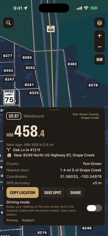
Your highway and mile marker to the tenth, which way you're headed, and the next sign ahead. In town, the street address instead.

  • Nearest crossroad and nearest town
  • County and GPS coordinates
  • One line to copy or share
Mile Marker TX reading card on US 87 near Grape Creek at mile marker 458.4 westbound
MM 2

Find any marker

Type a highway and a number, a county road, a street address or coordinates, and route to it right inside the app.
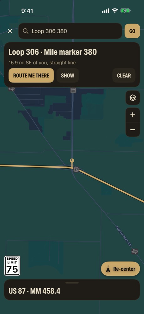
  • "Loop 306 380", "I-10 400", "CR 101"
  • Street addresses from 911 data
  • Turn by turn, with no voice
Search results for Loop 306 mile marker 380 with a Route me there button
MM 3

Mark the gates and tanks

Long-press to drop a pin, pick a kind, and it shows in its own color over the map or satellite.
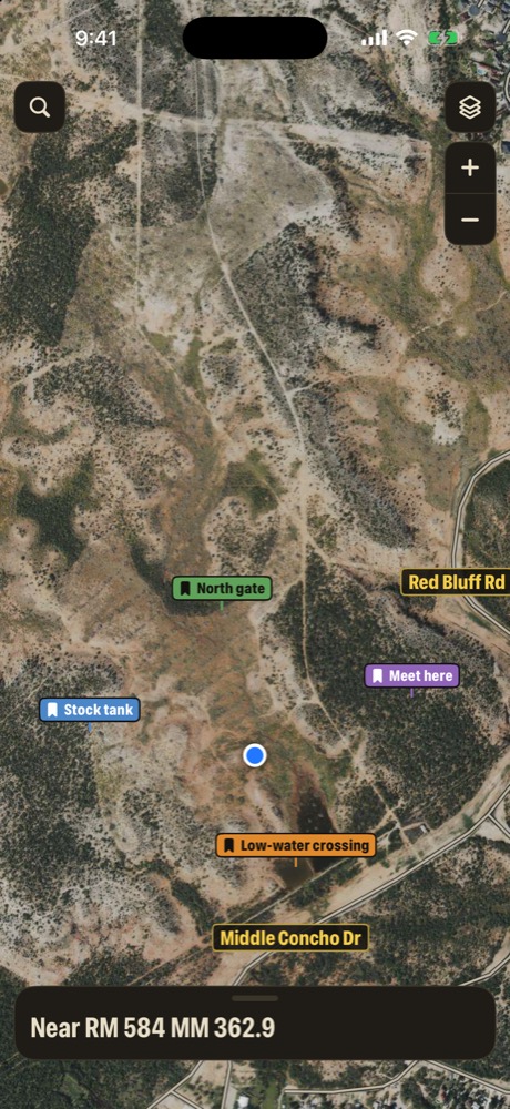
  • Gate, Water, Road hazard, Lease / well site, Meet point
  • Keep them to yourself or share with your crew
  • Save the spot you're standing on
Satellite map with colored pins named North gate, Stock tank, Meet here and Low-water crossing
MM 4

Out of signal, still on

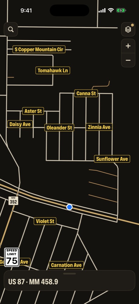
Every marker and street address lives on the phone. Switch on the offline map and the app draws the roads itself.

  • Readings never need a signal
  • Offline map with street names and signs
  • Satellite, directions and groups need signal
Offline map of streets near Grape Creek with street names and a mile marker sign
TX 254

Every county in Texas

All 254 counties, in 24 regions. Every posted TxDOT mile marker on the interstates, US and state highways and FM and RM roads, 12.1 million 911 addresses, and publicly recorded landowners from county appraisal records.

The Concho Valley comes built in. Download the other regions you drive, and they work offline too.

Your location is never sent to us

No tracking. Apple's map services use your location to draw the map, and your group sees it only if you choose to share. Read the privacy policy.

In an emergency, call 911

Mile Marker TX doesn't contact anyone for you. It tells you exactly where you are so you can say it clearly. Check it against the posted signs when you can, and set it up before you drive.

MM TX

Know where you are.
Anywhere in Texas.

Coming soon · FreeApp Store for iPhone
Questions? Email us
Mile Marker TXComing soon to the App Store
Features
Mile Marker TX screen for mile markers to the tenth
MM 1

Mile markers to the tenth

The reading card answers "where are you?" the way Texas roads do: by highway and mile marker. It updates as you drive, down to a tenth of a mile.

  • Mile marker to the tenth, measured along the road between the posted signs on either side
  • Direction of travel and the next sign ahead, with how far it is
  • Nearest town, county and GPS coordinates when you swipe up
  • Copy location gives you one clean line to read to 911, a tow truck or your crew
  • Every marker is stored on the phone, so the reading works with no signal
Mile Marker TX screen for every 911 address
MM 2

Every 911 address

The same address points 911 dispatchers use are built into the app, so in town your reading turns into a street address.

  • 12.1 million 911 address points across Texas
  • The card shows the nearest address as you drive, and switches to a full address card on city streets
  • Type a house number and street, and the map flies to the house
  • House numbers can be drawn right on the map
  • Address search works offline, because the data lives on the phone
MM 3

Who owns the land

Tap any property to see what the county appraisal district has on record. Turn on landowner labels and owner names print right across the land.

  • Owner, acres, property address and mailing address
  • Legal description, property ID and tax year
  • Route me there or save a pin straight from the property card
  • Think the owner is wrong? Report it, and it's checked against appraisal and deed records before anything changes
  • From public county appraisal records, published by the Texas Geographic Information Office
MM 4

Ranch roads and tracks

Out past the pavement, the map keeps going. Ranch tracks and private roads are drawn in, and county roads are labeled like the signs you see on them.

  • Private roads and ranch tracks from U.S. Census map data
  • Every county road labeled sign-style, "CR 411", repeated along the road
  • Named county roads labeled too, like "Aldwell Ranch Rd"
  • Turn tracks, road names and house numbers on or off
MM 5

Miles from the highway

County roads don't have mile markers, so the app gives you the next best thing: how far you are, by road, from the highway it meets.

  • Driving miles along the county road back to the state highway
  • That highway's mile marker at the junction
  • One line you can read out: "CR 101, 2.5 miles north of the highway at mile marker 458"
  • If a road never reaches a highway, you get the nearest marker and its distance instead
Mile Marker TX screen for next crossroad
MM 6

Next crossroad

Watching for your turn onto a county road? The card tells you what's coming before you get there.

  • The next county road ahead, like "CR 101 in 0.8 mi"
  • Measured along the road you're on, not as the crow flies
  • The nearest crossroad is in the details card too
MM 7

Your crew on the map

Working a lease, a hunt or a cattle drive with other people? Put everyone on the same map.

  • Join with a share code of 6 or more characters. Only a scrambled version of the code is stored online
  • Pick the name your group sees, and turn Share my location on when you want to be seen
  • Share pins with the whole group, or send one to a single person, who can accept or decline it
  • Stop sharing, or delete everything you've shared, any time
MM 8

Driving mode

Turn on Driving mode and lock the phone. Your reading stays right on the lock screen and in the Dynamic Island.

  • Highway and mile marker on the lock screen and Dynamic Island
  • Keeps reading with the phone locked, and iPhone shows its location indicator
  • Starting a route turns it on for you
  • Switch it on from the map menu or the reading card
MM 9

Turn alerts, no voice

Directions without anyone talking over your radio. Each turn gets a silent heads-up on your phone and a tap on your wrist.

  • Half a mile before each turn, or a mile at highway speed, and again about 500 feet out
  • Apple Watch taps your wrist when the phone is locked
  • Time Sensitive alerts, so they come through Driving Focus
  • Created on your phone, never sent through a server
MM 10

Ask Siri

Hands on the wheel? Just ask.

  • "Hey Siri, where am I in Mile Marker TX"
  • Siri reads back your highway and mile marker, or your street address
  • Answered from the data on your phone
Mile Marker TX screen for your map, your way
MM 11

Your map, your way

Set the map up the way you drive.

  • Turn with the road, or keep north up
  • Pick your arrow color
  • Show or hide house numbers, landowner names, road names, and private roads and tracks
  • Switch between the dark map, satellite, and the offline map drawn from your phone
Mile Marker TX screen for coordinates too
MM 12

Coordinates too

One search box takes whatever you've got: a mile marker, an address, a county road, or coordinates in any format.

  • Highway and marker: "Loop 306 380", "I-10 400"
  • County roads, street names and house numbers
  • Coordinates: decimal degrees, degrees and minutes, degrees minutes seconds, UTM and USNG/MGRS
  • Paste a Google Maps or Apple Maps link
  • Then tap Route me there for turn by turn directions inside the app